A Day Trip on the Massachusetts South Shore

In Massachusetts, when we say “North Shore, ” we’re talking about locations on the coastline, North of Boston. The South Shore is locales South of Boston. While I live relatively close to the South Shore, I have not spent a lot of time exploring that area, so I chose a cold day in January to accomplish that objective.

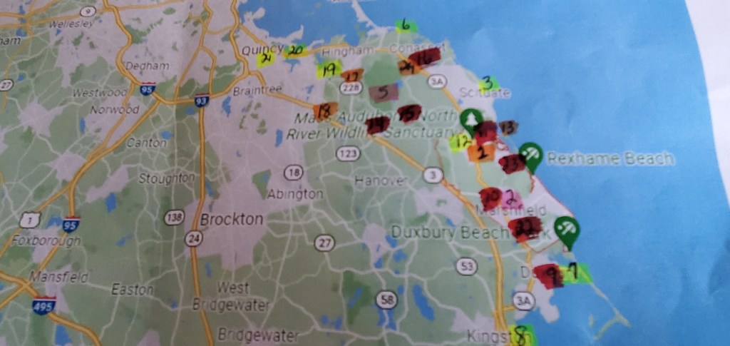
I spent a couple of days in my typical research, creating the map shown above. This helps me to know which direction to head and in which order to visit my destinations while minimizing travel time and backtracking. The numbers correspond to a list not pictured here, with detail about what the item is, and the colors reflect a coding system. Red = eating locations, pink= hiking, etc.

When putting this day together, I expected Jay, my most frequent travelling companion, to be joining me, but when he was unavailable at the last minute, I put a text out to my Tribe of 6 friends to see if anyone had interest in my little adventure. Jeanne responded that she was available, so at about 9:30 on that Sunday morning, we departed in my car equipped with plenty of warm weather gear, snacks, and my map. Although very cold, we had a sunny, mostly wind free day.

While I usually like to start my day trips with a hike, we decided to forego that particular activity on this day, as the temperature at 9:30 in the morning was still in the single digits. We were heading from South to North, with our first stop being Gray’s Beach in Kingston. A beach on a New England January day you might ask? Yes! This turned out to be a nice surprise. A very clean beach with plenty of parking and just a few steps to get to the sand. Also gorgeous views. There wasn’t a soul in sight. I will come back in the summer to see this beach in its prime season. We took a moment to read a couple of signs regarding erosion and beach rules and after snapping a few pictures, got ourselves on the road again.

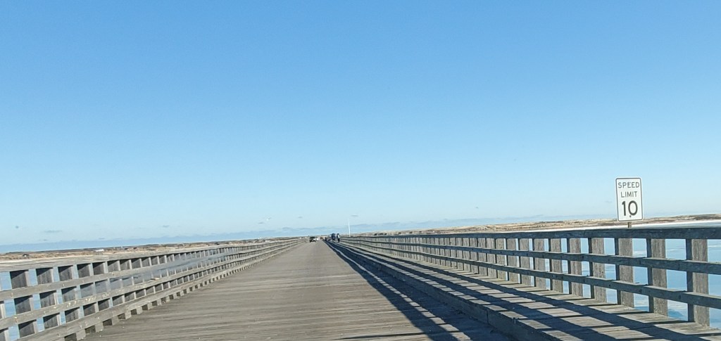
As we left Kingston, we wanted to take a scenic route that would bring us as close to the water as possible. This turned out to be Bay Road, to Washington Street, which brought us into Duxbury. We stopped once or twice to enjoy the views, marvel at some of the beautiful homes on the water, and take some pictures. When we arrived in Duxbury I set the GPS to Powder Point Bridge, which looked to be a relatively long bridge crossing the ocean. The bridge was very cool, looking more like a boardwalk for walking. I wasn’t sure what was on the other side but when we arrived there, it turned out to be Duxbury Beach, a narrow strip of land with beaches on either side. The majority of the parking was for Duxbury residents only, but there was a smaller parking lot for others. The beach area and parking lot were pretty well populated considering the time of year. We got out and walked briefly, enjoying the ice and snow on the beach and taking some more pictures before heading back to the car and back over the Powder Point Bridge.

Powder Point Bridge, Duxbury, MA

At this point we were ready to take a break from the great outdoors and headed to Marshfield and the Marshfield Hills General Store for a little browsing. It had a small sign, and we almost passed it but I spotted it at the last minute and hit the brakes to turn into the dirt parking lot. It wasn’t busy, just one or two cars other than us in the lot. We entered and gave a quick look around to see what we were dealing with. I didn’t know it just then, but we could see basically all of the store with that glance. It was very cute, a quintessential country store, albeit small. As we started to browse, I was surprised at the variety of items they had managed to include: Toys, fresh coffee, cards and gift items, baby merchandise, and a small market complete with canned goods and wine and beer. Some customers were helping themselves to the self-serve coffee and chatting comfortably with the proprietor, I’m guessing the owner. They had obviously been in the store before. I spent some time checking out the wine selection, always on the lookout for a local label when I’m in a new place. I briefly checked out the market, keeping my eyes out for a red pepper jelly that my daughter had fallen in love with a couple of weeks ago and liked to include on her charcuterie board. The market selections were more on the everyday side. I continued to circle the space, reading a couple of greeting cards and admiring a bracelet in the jewelry section before finding myself back at the door. A cute place, worth the visit, but ultimately didn’t inspire any purchases.

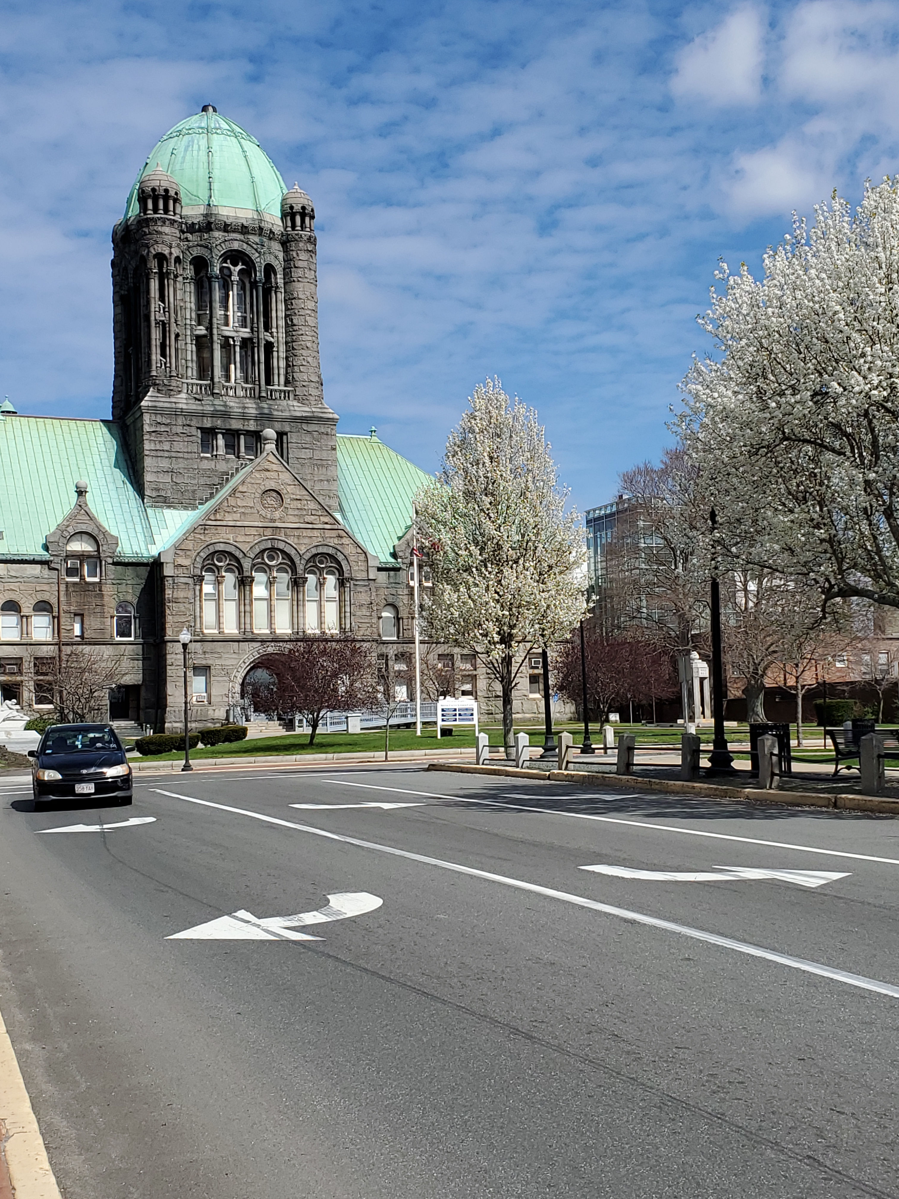
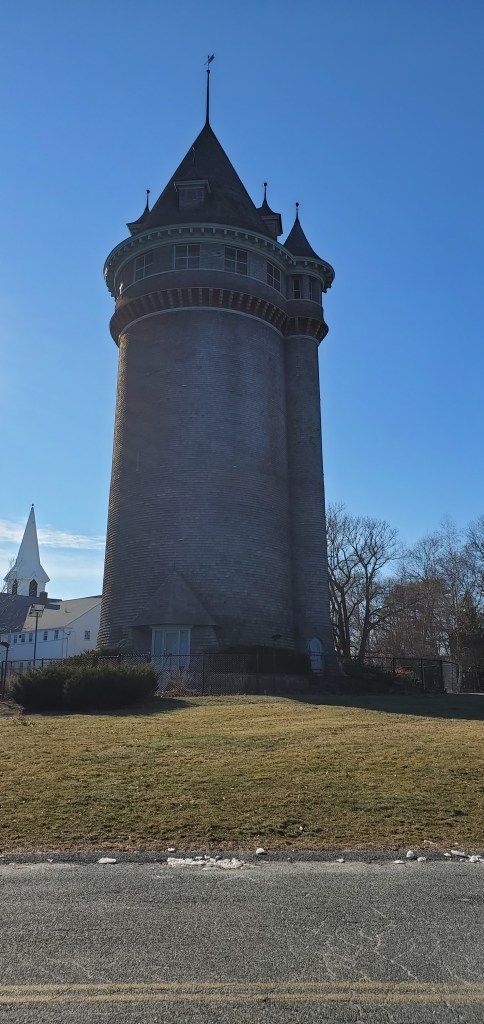
Our next stop–#12 on the map–was Lawson Tower in Scituate. Lawson Tower was once a water tower, built in 1902 and later enclosed by a wooden structure, on the style of a European castle turret, by land owner Thomas Lawson who was upset by the view the tower offerred. Jeanne and I share a love of backstory, so once we located the Tower, and parked, we read about the history and current use. There are 10 bells at the top of the Tower ranging from 300 to 3000 pounds. The Scituate Water Company stopped using the tank in 1988. Further googling revealed that it is sometimes opened to the Public for small events including sunset viewing.

Lawson Tower, Scituate, MA

After snapping some selfies, we checked the map and discovered we were pretty close to a “must-see” on the agenda, Scituate Lighthouse. Jeanne had been here before and agreed it was a sight we couldn’t miss. It was only a few minutes away and we found it with no difficulty. The sight has a large parking lot and although it was nowhere near filled, there were definitely other visitors present on this day. The Lighthouse is very accessible and was right at the edge of the the parking lot. A rock jetty sat behind the lighthouse and was easy walking, offering us gorgeous views of the ocean. We wandered for 15 minutes or so, snapping pictures, reading informative signs and chatting. Jeanne’s last visit to the Lighthouse, which was built in 1811, was in the evening and so she was able to see the lights in action. The lights had been out of commission for 134 years, finally being relit in 1994. The Lightkeepers cottage is right on sight.

We finally made our way back to the car, relieved that it had held some heat while we were exploring, and we were surprised to see that it was 1:30. Time for one of my favorite parts of any day trip: Lunch and a drink! We reviewed, and discarded, several eating options, based on either a lack of variety with the menu, or being a little more upscale than what we were looking for. We finally settled on The Fours, a restaurant in nearby Norwell that seemed to have a substantial menu and looked to be more pub-like than some other smaller venues.

The Fours turned out to be very popular and had a full parking lot, even at 2 o’clock in the afternoon when we arrived. Some of that mystery was solved as we entered the restaurant and discovered multiple tv’s displaying an NFL playoff game. The place was hopping and when we requested a table for 2 we were happy to accept the offer of a hightop and we were then seated immediately.

Our waitress came over quickly and gave us our menus and a friendly greeting. We both began to review our drink and dining options, which were considerable. I love a good IPA so I ordered the local Mayflower IPA and Jeanne selected a more light Blue Moon Belgian White. The food selections were more difficult as they had a great variety of appetizers, burgers and sandwiches. Everything sounded so good! We finally settled on sharing an order of buffalo chicken nachos and some chicken quesadillas. In addition, we each ordered a cup of clam chowder.

Our beers came quickly and we chatted while we sipped our drinks and enjoyed the atmosphere and each others company. The place was packed and it took a while to get our food but we honestly didn’t notice as we were having such a good time. Once our food arrived we dived right in and were not disappointed with any of our selections. We made a good choice in the restaurant and were almost reluctant to leave at about 330. But our adventure was not over yet and we were running up against limited daylight.

We began to make our way to our next Town destination, Cohasset. There was a drive I was looking forward to on Jerusalem Road that ran along the water and boasted of some beautiful mansions. On the way, there was an antique store we decided to stop at called Patina’s Antique Mall. We located Patina’s in a small shopping Plaza and were surprised from the outside at the apparent small size and also concerned as to whether or not it was open. A sign on the door pointed us to an entrance at the back of the building and when we drove around, we could see that it was a much bigger operation than it appeared from the front. It was close to their closing time and so we quickly headed into the store to check things out. It was a very typical antique location; very crowded with a wide variety of different objects mixed in together. We wanted to be respectful of the looming closing time so we moved quickly through the aisles, pausing to look at a vinyl record collection, in addition to numerous unique items. Recently I have been on the search for some colored glass items to add to my hutch, which lacks a little color. I ended up purchasing a small cranberry glass dish, which I knew would fit well with the rest of my glassware.

As dusk was starting to set in, we headed for our drive along Jerusalem Road, just a few minutes away from Patina’s. This experience was just as we had hoped, with each gorgeous residence and water view more impressive than the last. We marvelled at the size of some of the structures and wondered what size families lived there and what they did for a living. There was minimal traffic so we took our time, stopping once or twice to take some photos, before finally deciding to begin the trip home.

The day was a great success. We had beautiful blue skies and bright sun all day. Although the temperatures were chilly–between 20 and 30 degrees–we had very little wind and with our warm winter outergarments, we were actually quite comfortable out in the elements. We saw some amazing sights, got some fresh air and exercise, had a great meal, and thoroughly enjoyed one another’s company for about 8 hours. There were a few things we didn’t get to on my list of potential stops so who knows, we may try for round two of the South Shore Day Trip. Then again, there are just so many other interesting places to see!

A Solo Day Trip Might be Just What the Doctor Ordered

If you’ve been paying attention, you know I love a good day trip. From the choosing of a location, to the planning and timing and mapping out of desired stops, to discovering something surprising, I love everything about it. One of the best things is grabbing a spouse, daughter, son, sibling, friend or group of friends to share the adventure. But sometimes no one is available to join you. This happened to me recently. It was Father’s Day weekend and my kids were spending time with their dad, my boyfriend was hanging out with his son, and a quick text to my friend group returned similar responses of plans already made for that day.

Cut to me excitedly rubbing my hands together, thoughts already swimming in my head. What? I can go wherever I want? So yes, I decided to venture out on my own. Since it was early spring, I immediately knew I wanted to include some flower viewing on my agenda, so I checked my lists for places that might fit this requirement. After pinpointing a neighborhood famous for its tulip gardens, and a nearby farm boasting of its beautiful flowers, I decided on an area, about 40 minutes from my house. From there I filled in some more gaps with a hike, a local spot with beautiful trees, and a lunch stop. The only thing left was to map out my stops, fill my coffee mug, and hit the road.

Although I often like to start my day trips with a hike, today my first stop was in the center of my hometown, where there are beautiful trees and flowers that were currently in bloom. I parked on a street and took a walk around the common, snapping pictures as I went. It was a beautiful sunny day with lots of blue skies and everything looked amazing. I spent quite a bit of time here taking photos at different angles and aiming to get some beautiful historical buildings in the background (see photo above). Already I am enjoying the fact that no one is sitting in the car, impatiently waiting for me to finish. When I was ready I hopped back in my car and drove a little further down where there is a fountain and a nice circle of tulips surrounding it. I continued to meander, taking my time and snapping pictures. Today, I only had myself to please.

Next, I headed for my hike, ensuring I get in my exercise, and also a little quiet time. This was particularly true on this day. I had selected a spot on the water but as I headed that way, I passed several additional, unplanned spring trees in full bloom so I did something I never would have done had I not been alone: I stopped randomly to take pictures of the trees lining the roads and even stopped to take a picture (discreetly) of someone’s yard! I was consciously aware of how nice it was to not answer any questions like “where are we going?” or “why are we stopping here?”

Although well behind schedule–with no one to care–I did finally make it to my planned hike, a Mass Audubon property. I had read that the main trail, which was about 2 miles long, was a loop, which I tend to prefer as it means I don’t generally have to worry too much about watching for turns and trail markers. The path should start and stop in the same spot. I set out and was immediately slowed down by the beautiful scenery and my need to take pictures. The trail started off in a large field where I saw many different kinds of birds, before disappearing into a wooded area, that I soon realized took me on a path that ran along the ocean. It was gorgeous. I’m continuing to get behind schedule but no worries, guess why? It’s just me! There’s no one else I have to please. No one groaning that I’m stopping again, or hinting that they’re hungry and its time for lunch, or that they’re tired of walking.

I continued on the path, which eventually led through an area where the water became a stream and there were several times when I crossed a brook via a rock bridge or wooden bridge. In a particularly muddy section, a boardwalk had been constructed to making passing easier. One spot even had a bench for pausing to appreciate the view. I passed an osprey nest with two birds in it, and a farm area complete with sheep. Around the time I thought I should be coming to the end I started to see the trail opening up and as I looked around, I realized I was not in the same spot where I had parked. It was indeed the end of the road, however, so , I had obviously missed a turn somewhere and needed to turn around. I was a little frustrated at this development as it probably meant a significant amount of time would be required to retrace my steps. However, I was once again glad that I only had to deal with my own disappointment, and not someone elses. I headed back at a brisk pace, and soon discovered where I had gone wrong, arriving back at my starting point in record time.

The next decision about where to go was, again, mine alone, and since I was hungry, lunch seemed a good option. I had selected a well-reviewed bar pizza restaurant as bar pizza is not only one of my favorites, but also is not a a favorite among my family and therefore, a good option for a day on my own. I thoroughly enjoyed my pizza–at the bar of course– and was ready to move on with renewed energy. I think if I’d had a travelling companion, this might have been the final stop for the day, having made several stops already, but I did not have a travelling companion and I still had things to see!

My last stops were the tulip neighborhood and farm. While the neighborhood was not as easy to locate as I had hoped, it was still a beautiful location and on my way I passed a couple of other signs for parks that looked like they might be interesting to visit. I was starting to run out of time so I made a note of them to investigate on another day. I made a quick stop at the farmstand, picking up some beautiful cut flowers and vegetables, before jumping back into my car for the ride home.

The day was a very enjoyable for me for many reasons: beautiful scenery, picture opportunites, good food and a relaxing flow. The main benefit was the ability to stop, change, alter, and enjoy the scenery and schedule. I enjoyed being alone, and forging my path, adjusting, altering, never worrying about what someone else would want, if someone else was bored, tired, hungry. As I look back, it was heaven. I often keep track of places I’d like to visit, and as I’m making notes of those, I’m thinking that some of these are only interesting to me, and therefore best explored alone. In fact, I’m already planning the next one. All I need now is a day to myself!

How to Plan the Perfect Day Trip

Clockwise from top left: Brewer Brook Trail, Wachusett dam and reservoir, Interior-Clinton Tunnel, Exterior-Clinton Tunnel

I’ve always enjoyed a good day trip, and in this past year I’ve turned my interest into an art form. For me, a day trip is the perfect way to see new, interesting places, enjoy beautiful sights, and connect with friends or family. Don’t get me wrong, I long for future days of Caribbean and European vacations, as well as long weekends away. But for now, a day trip is an inexpensive way to rejuvenate and have some fun.

I’m going to share my planning strategies and a recent day trip adventure. And in case you don’t enjoy the planning piece of it as much as I do, follow my blog as I’ll continue to share preplanned day trips you can take in the future.

I am lucky enough to live in Massachusetts. There are many things I love about New England, but topping that list is the ability to quickly travel by car to several different states. In addition to MA, I can easily be in Connecticut, Rhode Island, New Hampshire, and even Maine or New York for a longer day trip.

When I decide to plan one of these adventures, I figure out how much time I have for that day, and who my travelling companion will be. My fellow traveler is important as I try to plan activities that I think they would enjoy. For example, if my daughter Bridget is going to join me, I’ll plan to visit thrift or antique stores.

Once I’ve identified my co-pilot, I start to peruse the ongoing lists that I maintain of possible places to visit (for more on my list compulsion see my recent blog “A list for the lists”!) I’ll pick out one or two activities that match my guest, and timeframe for travel, also taking into account seasonal activities and weather. Once I’ve identified that my top activities are feasible for that day, I might google the area or trip advisor to fill in some more possible stops. You might just like to wing it and drive out there and see what ‘s what, but I personally like to have at least 3 ideas of places to stop prior to heading out for a long drive. Honestly, I usually plan more items than we can feasibly accomplish. This allows for surprises–such as rain, or a spot being closed unexpectedly–and it also allows my travelling companion to have some say in what we do. I can show them the list of possibilities and let them select their favorites.

If I’ve found 2 or 3 main activities and I know we’ll have more time to spend, I’ll fill in with some favorite activities by googling the area by topic: Country stores, hikes, and restaurants top this list of possibilities.

Lastly, I print a map (yes, paper!) of the area and mark our potential stops. This gives me a better idea of how much time we’ll need, and also will help me plan the order of activities so we aren’t constantly backtracking because we aren’t sure which activity is closest.

After this, the only thing left to do is pack some snacks and hit the road!

Here’s how a recent day trip went with my 17 year old son, Dylan, during his recent school vacation. Dylan and I had about 5 hours to plan on this day. Rain was predicted late in the day so I knew I would want to schedule any outdoor activities earlier in the morning. As I started to review my list of ideas, I kept in mind that Dylan likes to see unusual things, especially if they might be spooky, and he also loves taking pictures. After running down some ideas, I decided to begin with an abandoned railroad tunnel in Clinton, MA. This offered both photo opportunities and an eerie atmosphere that I thought he would like. Also added to my list was the Wachusett dam and reservoir which looked interesting and appeared to be close to the tunnel. After this, I searched the area for a picturesque hike that would be close by, as I love starting my day in a peaceful environment with pretty surroundings and the opportunity for a little exercise. This search yielded Brewer Brook dam trail, in nearby Berlin, a 1 1/2 mile, relatively easy trail around a small lake. I figured these 3 activities, followed by a nice lunch, would make a great day. I mapped out the locations, filled Dylan in on the plan, and declared a 9:00 a.m. start time.

I was very happily surprised to awaken to a beautiful, sunny day. Since I’m an early riser, I had plenty of time to pack up some snacks and water, as well as making sure I was prepared for rain or mud (on our hike) by packing a sweatshirt, umbrella, and boots. Based on the map I had created, our itinerary looked like this:

1 Hike at Brewer Brook Trail

2 Clinton Rail Tunnel

3 Wachusett dam and reservoir

4 Lunch at restaurant of Dylan’s choice

We left at about 9:15, almost on time! Not bad for a morning trip with a teenager on spring vacation. Our first stop would be the hike, and GPS had us arriving there in about an hour. We had a relaxing drive with minimal traffic and located the parking area for the trail fairly easily. The trail map in the parking area showed an easy loop around a pond, so we set off with our cameras ready. The trail appeared well traveled and well marked. We came quickly to the lake and noticed in the water a teepeed fencelike construction, and when I wondered what it could be, Dylan had already figured out that it was an outlet that the water fell into (photo, above). I had never seen anything like this before but after reading about it after our day was over, I learned that it was for flood control.

As we headed to our left, with the lake on our right, we easily found the trail, marked with orange stripes on the trees, and headed into a more wooded area. It was a narrow path that followed pretty closely to the lake. Dylan was the first to spot a long, tree limb that had fallen to the water and was filled with small turtles sunbathing. As they heard our approach they dropped into the water one by one and by the time I could pull out my phone for a picture, there were only one or two left. It was not much further that we found a sign on a tree describing the beaver lodge. We could see evidence of beavers in the holes surrounding the dam at the lake’s edge, and also saw many chewed branches, further evidence of their presence, but we didn’t actually see any beavers. We continued our path around the lake and Dylan pointed out several black snakes as we walked.

When we came to the end of the lake and were starting to make our right turn to come around the other side, our trail markings suddenly became white instead of the orange we’d been following. We were clearly heading in the right direction, so we continued on the path, with the lake now a somewhat more distant presence on our right. It wasn’t long before we started to see some junk piles in a clearing, and eventually a couple of houses, and it became clear we had veered off the trail. We decided to continue forward, after consulting our phones and seeing that we were close to the road. Eventually we came to a small dirt road and passed several more houses, obviously in someone’s yard, but there was no turning back at this point. Soon we arrived at the main road, and it was a short walk back to the parking area.

This was not my first time getting lost on what seemed like such an easy trail to follow. Despite all of my hiking, my inner sense of direction has not gotten any better. I really wanted to go back and try to find out where we had gone wrong, but we had other things we wanted to see, so we grabbed some water in the car, and got back onto the road. Someday I will go back and find the right path.

Our next stop–the tunnel– was just 10 minutes away, so we found the graffitied stones that marked the tunnel pretty quickly. I could not see the tunnel entrance or any parking, but as we passed the area, Dylan spotted a set of stairs that he suspected led up to the entrance of the tunnel. When we turned around to find a spot to pull over, we saw the Wachusett dam and reservoir almost directly across the street and decided to stop there first. This area had some street parking and was more heavily populated with people. Immediately we could see a great view of the reservoir on the left, with the very steep dam in the middle, and views of the city off to our right. We strolled over to a steep set of stairs leading to the bottom of the dam, taking a lot of pictures as we went along.

We took the steps to the bottom where we wandered through a little park with some trees and a fountain, again taking pictures and stalling a little at the thought of climbing the steep and lengthy staircase back to the top. Eventually we knew we had to get going, so we slowly made our way back to the top. Many people were sitting on the lawn, or the short concrete walls enjoying the views and the beautiful day. We finally made our way back to the car for the short drive back to the tunnel.

We parked on the side of the road and climbed a small embankment where we immediately saw the entrance to the tunnel. Graffiti was plentiful here. There was another couple walking through the tunnel so we paused to take some pictures and Dylan climbed up the side of the tunnel and sat at the top. Once the other couple were out of view, we entered the tunnel where the temperature dropped at least 10 degrees. It was only 2/10 of a mile long and we could see daylight at the other end. Dylan did not really appreciate my joke that we were literally seeing the light at the end of the tunnel.

As we ventured in further it got darker and darker and eventually we needed the flashlights on our phone to see where we were walking. Several areas had leaks and water dripped down, or poured down in a couple of places, and we had to watch out for puddles. As we had anticipated, it was a little spooky walking through the tunnel and I shuddered to think how dark it would be at night. Some people obviously had had that experience as there was quite a bit of trash left in the tunnel. I found myself wishing that anyone who came to enjoy the tunnel would at least clean up after themselves so that others who came after them could enjoy it. We made it to the other end relatively easily and paused to take some more photos before heading back through the tunnel to the opening where we had entered.

Soon we were back in the car and ready and hungry for our final stop: Lunch! I had selected 3 or 4 nearby restaurants based on 3 criterium: Good ratings, good food selection, and a liquor license. Cuz mom gets thirsty after a morning filled with activities.

Dylan selected a place called O’Connors, an Irish Pub in nearby Worcester. As we pulled up we could tell we had picked a winner, as the lot was filled, even at lunchtime on a Wednesday. They had some nice outdoor seating but it had started to rain a bit and we gladly made our way inside, where we waited only a minute before being seated. O’Connors is an old fashioned pub with many little rooms so although there was a lot of seating, we felt like we were in a room to ourselves. Service was prompt and we ordered drinks while continuing to review the lengthy menu. Dylan ordered his usual chicken fingers and I had a “grownup” grilled cheese (cheddar and brie) with a cup of butternut squash bisque. We both thoroughly enjoyed our food and we had great conversation about our day and other things going on in our world.

After a very enjoyable day, it was time to head home. We got a lot in in a short time, combining exercise, interesting sights, good food, and good conversation. Overrall, a very successful day. Oh by the way, total cost for the day: $30, the cost of lunch. It was almost sad knowing the day had come to end. But never fear, plans are already under way for the next exciting day trip!